
Terada Gr
Type Locality and Naming
Comprises a lower Teragh Fm (arkoses and conglomerates). And upper Talak Fm (claystone) with its Akokan Mbr at the very top (and the laterally similar Aoulingen Fm (siltstone) – these are coeval with the Tim Mersoï Fm.
References: Joulia, 1959; Claret & Tempère, 1968; Valsardieu, 1971; Legrand-Blain, 1974; Fabre et al., 1983; de Rouvre, 1984, 1985, 1988; Conrad et al., 1986; Fabre, 2005
Synonym: “Série de Térada”
Equivalent(s): The Tim Mersoï Fm with its equivalent Talak Fm and Aoulingen Fm and the Teragh Fm make up the Terada Group. The Teragh unit is the equivalent to the upper portion of the Farrazekat unit of Joulia (1959) and Claret & Tempère (1968).
Lithology and Thickness
It begins (Teragh Fm) with conglomerates and boulder clays resting on a mottled and weathered surface. They are followed by marine gypsum and lumachelle clays of the Talak Fm (or coal and plant clays and siltstones (Rhacopteris) of the Aoulingen Fm) and topped by the sandstones, silts and clays of the Akokan Mbr when present. South of In Guezzam, the Tim Mersoï Fm is the equivalent of the Talak Fm and Aoulingen Fm west of Aïr (see Tim Mersoï Fm for its definition). Total of 290 m.
Relationships and Distribution
Lower contact
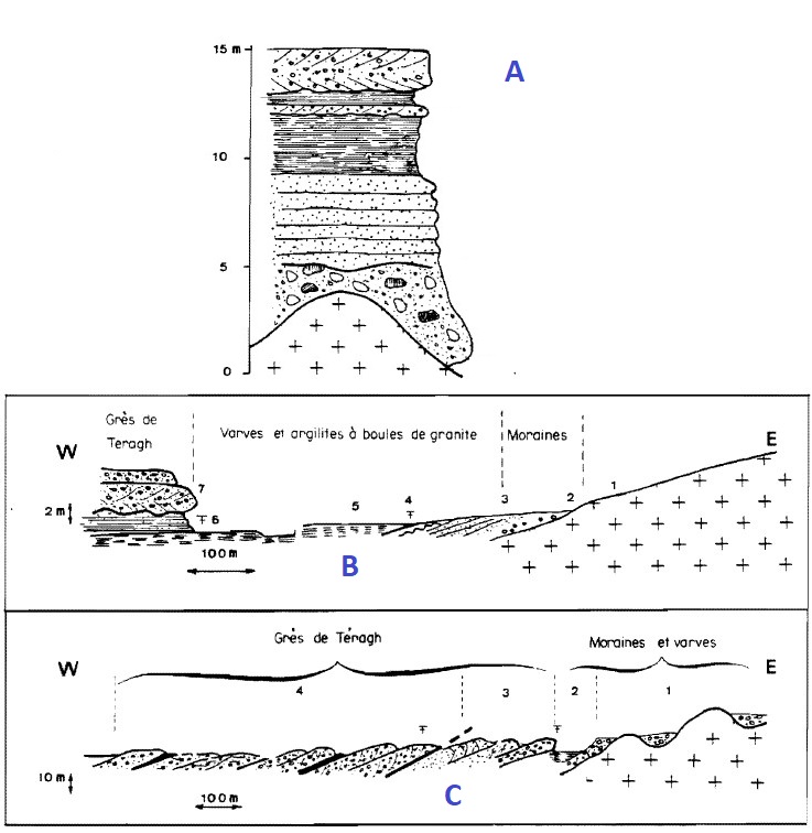
In the Tim Mersoï Sub-Basin, this Group represents the first terms of the sedimentary cover, discordant on the crystalline basement of the western flank of the Aïr. Underlain by the Farrazekat Fm, or the Precambrian Basement (Figure).
[Figure. Three diagrams showing the disposition of the Terada Gr over the Precambrian rocks in the Teragh region (Source: Valsardieu, 1971).]
Upper contact
The whole is deformed before the deposit of the following Guezouman Fm (Tagora Gr) and younger units.
Regional extent
GeoJSON
Fossils
Plants (de Rouvre, 1984, 1985, 1988).
Age
Depositional setting
Characterized by fluvio-deltaic to continental shelf deposits (Teragh Fm) to the marine sediments of the Talak Fm /Aoulingen Fm /Tim Mersoï Fm
Additional Information